
Interactive World Maps – Premium Customizable Clickable SVG Map Builder
Verified from VirusTotal 100% Original Product and Virus Free. Free New Version Lifetime On Single Purchase. Unlimited Website Usage Price is in US dollars and included tax
Buy confidently with secure digital checkout, account-based downloads, and a cleaner WPPlugShop product experience.
Preview Interactive World Maps – Premium Customizable Clickable SVG Map Builder
View the product artwork, switch gallery images, and open a larger preview before checkout.
Get secure digital access for real WordPress projects
This section summarizes the buying experience and what customers can expect after checkout.
Product overview, benefits, and digital access details
Review the key product details, practical use cases, and digital access information before checkout.
Product Overview
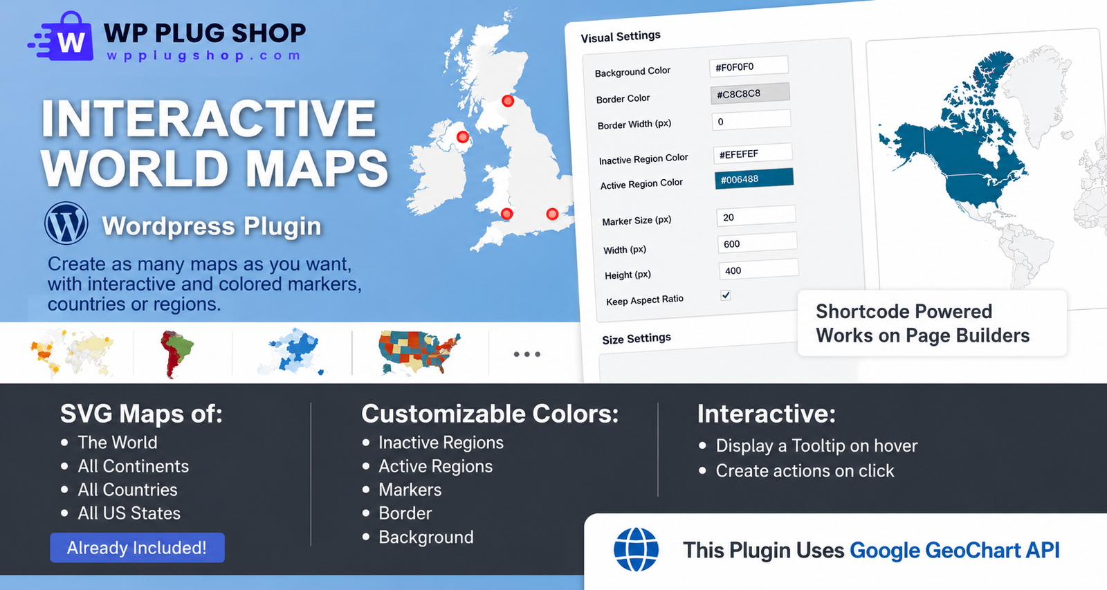
Visualizing geographic data effectively can completely redefine how users engage with your brand footprint, distribution channels, or content archives. The Interactive World Maps plugin is an elite, high-performance data visualization framework for WordPress designed to transform flat location lists into beautiful, clickable geographic experiences. Built using premium vector graphic engines, this plugin allows site owners and developers to embed completely responsive vector maps of the entire world, targeted continents, sub-regions, or specific countries without coding restrictions.
Whether you need to display global office branches, track corporate regional distribution, or create an interactive geographical navigation index for a travel portal, this module provides the exact workspace settings to do so flawlessly. Available as an un-encoded open-source digital asset via WP Plug Shop, the plugin leverages lightweight rendering configurations that keep your page sizes incredibly small. It bypasses heavy cloud-hosted API requirements to protect your database speeds while delivering stunning graphical interfaces out-of-the-box.
Why This Product Is Useful
Traditional map embeddings routinely suffer from two critical failures: they either drag down your front-end loading speed due to hundreds of external tracker requests, or they run up expensive monthly third-party API usage bills. The Interactive World Maps plugin addresses both issues simultaneously by utilizing localized, pure vector SVG rendering technology to build standalone, responsive map entities right from your hosting server.
The customization interface is highly optimized for fast workflows. You can select specific global boundaries, shade individual territories using personalized HEX color codes, drop coordinate pins on exact locations, and assign distinct click triggers. The plugin works seamlessly across modern design frameworks, making it easy to display localized pop-up data blocks or redirect international users to dedicated landing pages in just a few clicks.
Key Features
- Comprehensive Geographic Library Matrix: Instantly load pre-built maps covering the full global projection, continental blocks, specific sub-regions, or individual country maps divided by state or province.
- Dynamic Individual Region Coloring: Take control of your site aesthetics by mapping unique HEX colors to active and inactive regions to represent regional sales density or specific franchise territories.
- Interactive Content Hover Tooltips: Present responsive, descriptive pop-up panels containing formatted text, custom images, or dynamic shortcodes the moment a user hovers over any target zone.
- Flexible Cross-Platform Click Actions: Program customizable interaction rules for clicked paths—including triggering responsive modal lightboxes, executing custom JavaScript strings, or opening new page URLs.
- Precision Geographic Marker Pins: Drop highly recognizable pointer icons, vector badges, or custom icons onto precise coordinate positions using exact latitude and longitude inputs.
- 100% Mobile Responsive SVG Engine: Built entirely with scalable vector layers that automatically resize to look incredibly sharp on everything from standard mobile displays to ultra-wide desktop monitors.
Main Benefits
- Dramatically Boosts On-Site User Engagement: Replacing flat text directory lists with an immersive, clickable visual map encourages visitors to explore your content longer, extending average session times.
- Eliminates Expensive External API Keys: Operates independently of recurring, consumption-based cloud maps platforms, permanently protecting your agency from surprise monthly usage invoices.
- Maintains Lightning-Fast Page Loads: Clean inline asset processing means no bloated multi-script downloads, ensuring your interactive layouts keep passing core web vitals metrics with ease.
- Complete Visual Integration Freedom: Fine-tune boundaries, backgrounds, sizing properties, and interactive hover shifts using an intuitive backend panel that adapts smoothly to your existing theme styling.
Best Use Cases
- Global Branch Office Locators: Designing a custom administrative hub map where clicking specific country divisions opens corresponding corporate location data rows.
- Travel Blog Portfolio Navigation: Structuring a beautiful visual directory map where selecting an active territory automatically filters localized journal entries.
- International digital access Coverage Hubs: Equipping export stores or wholesale portals with real-time color-coded maps showing active delivery zones and regional duty tiers.
Who Should Use This Product?
- WordPress Agencies & Freelancers: Professionals looking for a powerful, reliable solution to present interactive geographical matrices across high-end corporate deliverables.
- Multi-National E-Commerce Brands: Store managers who need to map out regional storefront variations, logistics networks, or global marketplace channels.
- Non-Profits & Global Research Groups: Project administrators aiming to display field studies, local charity footprints, or project funding impacts visually.
WP Plug Shop Access Benefits
Securing your data visualization tools from WP Plug Shop ensures a highly optimized, fully unhindered development environment. We provide vetted, open-source alternatives tailored to function securely on production-grade infrastructure. Every package download includes:
- 100% Secure, Malware-Scanned Guarantee: Every plugin zip archive goes through exhaustive multi-layered file security tracking to verify completely clean source code.
- GPL Open-Source Freedom: Enjoy unrestricted distribution rights, allowing you to install, evaluate, and scale this mapping tool across infinite staging setups or live client domains.
- Instant Member Dashboard Delivery: Access your files instantly post-purchase from your member portal, with zero mandatory access detailss or mandatory activation codes.
Product Details
| Technical Parameter | Specification Detail |
|---|---|
| Plugin Development Category | Data Visualization & Geographical Mapping Utilities |
| Core System Dependencies | WordPress 5.1 or Higher Active Server Configuration |
| Graphics Engine Architecture | Scalable Vector Graphics (SVG) via Local Script Hooks |
| Page Builder Integration | Fully Compatible with Elementor, Divi, Avada, and Gutenberg Blocks |
| License Framework | General Public License (GPL) Compliant Open-Source Access |
Feature Comparison
| Mapping Interface Matrix | Standard Embedded Cloud Maps | Interactive World Maps Plugin |
|---|---|---|
| Page Optimization & Bloat | Loads heavy background tracking files that pull down speed scores | Loads lightning-fast localized SVG layers directly from your server |
| Regional Shading Control | Requires writing deep custom code layers or complex styling files | Provides simple HEX color pickers for individual regions and marker assets |
| Consumption Fees | Subject to variable, recurring monthly cloud service API billings | 100% free from usage locks with zero external data processing fees |
| Click Interaction Events | Typically limited to opening generic corporate address markers | Triggers modal lightboxes, runs custom JS code, or routes to custom URLs |
Pros and Considerations
| Advantage Checklist (Pros) | Operational Considerations |
|---|---|
| Enables endless aesthetic combinations using native color pickers and intuitive backend settings panels. | Requires inputting precise coordinates for markers when plotting custom city location points. |
| Embeds effortlessly across posts, headers, sidebars, and grid elements using clean shortcodes. | Relies on theme footer hooks to accurately run smooth visual tooltip transformations. |
| Total license freedom to modify and launch across multiple test setups and live domains. | The accuracy of boundaries relies on standard global vector templates built into the system. |
Final Verdict
When you want to replace boring text tables with a high-impact geographic interface, this extension delivers unmatched execution capabilities. The Interactive World Maps plugin bridges design elegance with total technical freedom, allowing you to craft striking, responsive visual maps tailored precisely to your brand guidelines. It is a fundamental asset for modern agencies looking to showcase a global footprint while maintaining peak site performance profiles.
Frequently Asked Questions
Do I need to upload my own geographic SVG files to use this plugin?
No. The plugin comes equipped with an extensive pre-built geographical template database directly out-of-the-box. You can load a unified layout of the entire world, choose specific continental zones, select individual countries, or target unique country sub-divisions and states straight from an intuitive administrative dropdown selector menu.
Can I display multiple unique maps on the exact same WordPress page?
Yes. The extension generates a unique tracking identification shortcode for every map profile you configure in your backend control panel. This allows you to embed multiple independent layouts—such as a global office map next to a localized regional delivery grid—within the exact same post or page builder section.
Does this map plugin require a Google Maps API license or key registration?
No. One of the primary advantages of this vector framework is that it functions independently of consumption-based cloud maps API systems. Because it processes localized Scalable Vector Graphics (SVG) structures directly from your web host, you will never have to worry about surprise monthly usage bills or tracking code restrictions.
What happens if a user visits my website using a smartphone or tablet?
The plugin includes a dedicated layout optimization engine that converts all generated vector templates into fully responsive elements. Utilizing responsive jQuery monitoring arrays, the map automatically tracks active viewport shifts to fluidly redraw boundaries and scale tooltips perfectly for iOS and Android mobile screens.
Can I configure individual regions to open modal popups when clicked?
Yes. The system supports flexible cross-platform action rules for click events. While you can natively set territories to route users to new page URLs or display simple message copy, you can also easily pair the plugin with popular open-source modal solutions (such as Popup Maker) to launch elegant information lightboxes on click.
Is it possible to assign custom images or unique icons as location marker pins?
Absolutely. The customization panel allows you to plot specific global locations using precise latitude and longitude inputs. You can choose to represent these locations using customizable colored bubbles, select from an integrated set of crisp vector icons, or upload your own branded graphical image files to serve as pins.
Can I color-code distinct countries or states individually to display sales data?
Yes. You have total creative control over the aesthetic style of your geographic matrices. The system provides universal background options alongside individual path selection variables, meaning you can assign separate, personalized HEX colors to targeted regions to easily display territory divisions, store maps, or franchise ownership zones.
Are there any licensing locks or domain usage limits on this marketplace archive?
None at all. Every digital utility distributed via WP Plug Shop is fully compliant with the open-source General Public License (GPL). There are zero built-in API validation keys, domain authorization locks, or hidden registration steps, allowing you to freely install and utilize the builder across infinite staging layouts and live production properties.
Quick product answers for buyers and AI search
Clear product answers help buyers, search engines, and AI answer engines understand this product faster.
Best ways to use this WordPress digital product
These use cases help buyers quickly decide if this product fits their workflow.
How digital access works
No physical shipping is required. This is a digital product access purchase designed for account-based downloads.
Secure payment options for digital checkout
WPPlugShop supports trusted checkout options so buyers can complete digital purchases with more confidence.
Frequently asked questions
Buyer-focused answers about digital access, secure payments, downloads, support, and product usage.
Related WordPress tools you may also like
Explore related WordPress tools that may support the same workflow, website type, or project goal.


Choose the right WordPress tool with confidence
Request a product, explore membership access, or contact support if you want help choosing the right WordPress digital product before checkout.